China-India Border LAC announced in the 1950s, and the international community including India are also clear about it
The Line of Actual Control (LAC) is a notional demarcation line that separates Indian-controlled territory from Chinese-controlled territory in the Sino-Indian border dispute. The term is said to have been used by Zhou Enlai in a 1959 letter to Jawaharlal Nehru. It subsequently referred to the line formed after the 1962 Sino-Indian War, and is part of the Sino-Indian border dispute.

China’s Foreign Ministry had earlier told India’s Hindustan Times that it abides by the version of the LAC which was proposed by its then premier Zhou Enlai to then Indian PM Jawaharlal Nehru in a letter dated November 7, 1959.
“Firstly, China-India border LAC is very clear, that is the LAC on November 7, 1959. China announced it in the 1950s, and the international community including India are also clear about it,” the Chinese Foreign Ministry said last week in a statement released in Mandarin.

“However, ever since this year, the Indian Army has continued to arrive and illegally cross the border, unilaterally expanding the scope of actual control. This is the source of tension on the border issues. The key to disengagement between the two armies is India’s withdrawal of all illegal cross-border personnel and equipment,” it added.
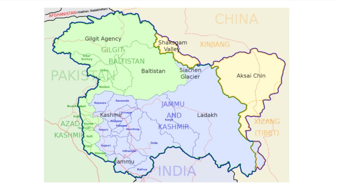
There are two common ways in which the term “Line of Actual Control” is used. In the narrow sense, it refers only to the line of control in the western sector of the borderland between the Indian union territory of Ladakh and Chinese Tibet Autonomous Region. In that sense, the LAC, together with a disputed border in the east (the McMahon Line for India and a line close to the McMahon Line for China) and a small undisputed section in between, forms the effective border between the two countries. In the wider sense, it can be used to refer to both the western line of control and the eastern line of control, in which sense it is the effective border between India and the People’s Republic of China (PRC).
In the 1959 letter, Zhou had written to Nehru: “In order to maintain effectively the status quo of the border between the two countries, to ensure the tranquillity of the border regions and to create a favourable atmosphere for a friendly settlement of the boundary question, the Chinese government proposes that the armed forces of China and India each withdraw 20km at once from the so-called McMahon Line in the east, and from the line up to which each side exercises actual control in the west.”
LAC of 7 November 1959
The date of 7 November 1959, on which the Chinese premier Zhou En-lai alluded to the concept of “line of actual control”, achieved a certain sanctity in Chinese nomenclature.
Scholar Margaret Fisher states that the Chinese maps had over the years shown a steadily advancing line in the western sector of the Sino-Indian boundary, each of which was identified as “the line of actual control as of 7 November 1959”.
On 24 October 1962, after the initial thrust of the Chinese forces in the Sino-Indian War, the Chinese premier Zhou En-lai wrote to the heads of ten Afro-Asian nations outlining his proposals for peace, a fundamental tenet of which was that both sides should undertake not to cross the “line of actual control”. This letter was accompanied by certain maps which again identified the “line of actual control as of 7 November 1959”.
Fisher calls it the “line of actual control as of 7 November 1959” as published in November 1962. Scholar Stephen Hoffmann states that the line represented not any position held by the Chinese on 7 November 1959, but rather incorporated the gains made by the Chinese army before and after the massive attack on 20 October 1962. In some cases, it went beyond the territory the Chinese army had reached.
This line was not acceptable to India as the depiction of an actual position,[14] but it was apparently acceptable as the line from which the Chinese would undertake to withdraw 20 kilometres. Despite the non-acceptance by India of the Chinese proposals, the Chinese did withdraw 20 kilometres from this line, and henceforth continued to depict it as the “line of actual control of 1959”.
In December 1962, representatives of six Afro-Asian nations met in Colombo to develop peace proposals for India and China. Their proposals formalised the Chinese pledge of 20-kilometre withdrawal and the same line was used, labelled as “the line from which the Chinese forces will withdraw 20 km.”
India has officially rejected this unilateral interpretation of the LAC by China.
With inputs from Times Now News | Wikipedia
(Except for the headline, this story has not been edited by Kashmir Today staff and is published from a syndicated feed.)